
Guidebook for Santa Clara
Food Scene
Cafe Rio Mexican Grill
15 S River RdHARMONS GROCERY
3520 Pioneer PkwyFabulous gelato, salad bar, specialty items + more.
Canyon Breeze Restaurant
1275 E Red Mountain CirCosta Vida
845 State StParks & Nature
Snow Canyon State Park
1002 Snow Canyon DrDinosaur Crossing
447 S Mall DrBryce Canyon National Park, a sprawling reserve in southern Utah, is known for crimson-colored hoodoos, which are spire-shaped rock formations. The park’s main road leads past the expansive Bryce Amphitheater, a hoodoo-filled depression lying below the Rim Trail hiking path. It has overlooks at Sunrise Point, Sunset Point, Inspiration Point and Bryce Point. Prime viewing times are around sunup and sundown.
465 vietiniai rekomenduoja
Braiso Kanjono nacionalinis parkas
Bryce Canyon National Park, a sprawling reserve in southern Utah, is known for crimson-colored hoodoos, which are spire-shaped rock formations. The park’s main road leads past the expansive Bryce Amphitheater, a hoodoo-filled depression lying below the Rim Trail hiking path. It has overlooks at Sunrise Point, Sunset Point, Inspiration Point and Bryce Point. Prime viewing times are around sunup and sundown.
The hike across the canyon from South Rim to North Rim is 21 miles (34 km). However, driving from the South Rim to the North Rim by automobile requires a five-hour drive of 220 miles (354 km). Driving directions to the North Rim...
The North Rim Visitor Center, located adjacent to the parking lot for Grand Canyon Lodge and Bright Angel Point, provides park and regional information, maps, brochures, exhibits, and a bookstore.
The visitor center is open May 15 through October 15 from 8:00 am to 6:00 pm daily. Interpretive ranger programs are offered daily during the season.
24 vietiniai rekomenduoja
North Rim
The hike across the canyon from South Rim to North Rim is 21 miles (34 km). However, driving from the South Rim to the North Rim by automobile requires a five-hour drive of 220 miles (354 km). Driving directions to the North Rim...
The North Rim Visitor Center, located adjacent to the parking lot for Grand Canyon Lodge and Bright Angel Point, provides park and regional information, maps, brochures, exhibits, and a bookstore.
The visitor center is open May 15 through October 15 from 8:00 am to 6:00 pm daily. Interpretive ranger programs are offered daily during the season.
Hidden Valley Park includes a playground, splash pad, 2 covered pavilions, picnic tables, barbeques, grass, lighted sand volleyball, 2 lighted tennis courts, and WiFi.
Hidden Valley Park
3505 Barcelona DrHidden Valley Park includes a playground, splash pad, 2 covered pavilions, picnic tables, barbeques, grass, lighted sand volleyball, 2 lighted tennis courts, and WiFi.
Sand Hollow State Park features a 1,322-acre reservoir for boating, jet skiing, swimming, and fishing along with an extensive off-highway vehicle recreation area on Sand Mountain next to the reservoir.
301 vietiniai rekomenduoja
Sand Hollow valstijos parkas
3351 Sand Hollow RdSand Hollow State Park features a 1,322-acre reservoir for boating, jet skiing, swimming, and fishing along with an extensive off-highway vehicle recreation area on Sand Mountain next to the reservoir.
This is a must-do hike in the St. George area! The Chuckwalla trail is accessed directly from the Chuckwalla
trailhead off of State Route 18 north of Snow Canyon Parkway. It is one of the
most popular trails in the Red Cliffs Desert Reserve because of its close proximity to residential areas, its friendly network of trails in Paradise Canyon, and
beautiful red
Chuckwalla Climbing Area
Chuckwalla TrailThis is a must-do hike in the St. George area! The Chuckwalla trail is accessed directly from the Chuckwalla
trailhead off of State Route 18 north of Snow Canyon Parkway. It is one of the
most popular trails in the Red Cliffs Desert Reserve because of its close proximity to residential areas, its friendly network of trails in Paradise Canyon, and
beautiful red
Amenities:
Softball Fields and Soccer Fields (Reservation Required)
Bleachers, Dugouts, Scoreboards, Storage Areas, Concession Stand, and Activity/Conference Room.
3 Park Pavilions (Reservations Suggested)
Basketball Courts, Playground, Splash Pad, Restrooms, Walking Trails, Bridge to Lava Ridge Intermediate School fields
The facilities are used for both local and visitor play of large and small groups: regulation softball tournaments, Huntsman World Senior Games, family teams, and more.
Reservations can be made by calling the Santa Clara Parks Department at (435) 673-6712 x219
Archie H. Gubler Park
2375 Rachel DrAmenities:
Softball Fields and Soccer Fields (Reservation Required)
Bleachers, Dugouts, Scoreboards, Storage Areas, Concession Stand, and Activity/Conference Room.
3 Park Pavilions (Reservations Suggested)
Basketball Courts, Playground, Splash Pad, Restrooms, Walking Trails, Bridge to Lava Ridge Intermediate School fields
The facilities are used for both local and visitor play of large and small groups: regulation softball tournaments, Huntsman World Senior Games, family teams, and more.
Reservations can be made by calling the Santa Clara Parks Department at (435) 673-6712 x219
Trails Master Plan Map
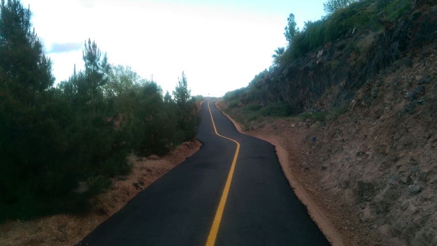
Cinder Trail (paved) is the newest trail. It runs between Cinder Circle and Claude Drive and connects the Vineyards with Black Rock Park.
The Lava Flow Trail (paved) begins at Canyon View Park (1400 Canyon View Drive), and then takes a route along Tuacahn Wash and through the Santa Clara Lava beds for more than a mile before it reaches Red Mountain Drive on the north side of Santa Clara.
Santa Clara City Arboretum has several winding and connecting unpaved trails leading through the underbrush and over lava rocks, with native plants, shrubs and trees neatly labeled. The main trailhead is located on the north side of Little League Drive, north of Little League Park.
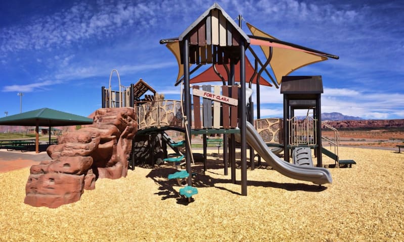
The Jacob Hamblin Trail begins at The Jacob Hamblin Home (3356 Santa Clara Drive) and continues west to the Fort Clare historic site monument. From there, it winds northwest along the hillside near Highway 91 and ends at the historic Santa Clara Cemetery. The length of the trail is .7 miles.
The Pioneer Leg Trail is a continuation of the Jacob Hamblin Trail. It begins at the Cemetery (4500 Ancestor Way), crosses Rachel Drive and continues to Pioneer Parkway. It currently continues along Pioneer Parkway for only a few blocks, but in the future, it will be extended further to the north, between Santa Clara City and the City of Ivins.
The Santa Clara River Reserve has miles of trails traversing BLM land along the Santa Clara River and in the hills above the winding river. It provides insight into the area’s rich history and views of Santa Clara, Ivins, and the Red Mountain. Maps of the trail system can be found at this link: https://www.blm.gov/visit
6 vietiniai rekomenduoja
Santa Clara
Trails Master Plan Map
Cinder Trail (paved) is the newest trail. It runs between Cinder Circle and Claude Drive and connects the Vineyards with Black Rock Park.
The Lava Flow Trail (paved) begins at Canyon View Park (1400 Canyon View Drive), and then takes a route along Tuacahn Wash and through the Santa Clara Lava beds for more than a mile before it reaches Red Mountain Drive on the north side of Santa Clara.
Santa Clara City Arboretum has several winding and connecting unpaved trails leading through the underbrush and over lava rocks, with native plants, shrubs and trees neatly labeled. The main trailhead is located on the north side of Little League Drive, north of Little League Park.
The Jacob Hamblin Trail begins at The Jacob Hamblin Home (3356 Santa Clara Drive) and continues west to the Fort Clare historic site monument. From there, it winds northwest along the hillside near Highway 91 and ends at the historic Santa Clara Cemetery. The length of the trail is .7 miles.
The Pioneer Leg Trail is a continuation of the Jacob Hamblin Trail. It begins at the Cemetery (4500 Ancestor Way), crosses Rachel Drive and continues to Pioneer Parkway. It currently continues along Pioneer Parkway for only a few blocks, but in the future, it will be extended further to the north, between Santa Clara City and the City of Ivins.
The Santa Clara River Reserve has miles of trails traversing BLM land along the Santa Clara River and in the hills above the winding river. It provides insight into the area’s rich history and views of Santa Clara, Ivins, and the Red Mountain. Maps of the trail system can be found at this link: https://www.blm.gov/visit
Sightseeing
Zion National Park
Zion National Park South Entrance Ranger Station
151-161 Zion – Mount Carmel HighwayThe Jacob Hamblin home is a historic residence and museum of the Mormon pioneer and missionary who founded Santa Clara in 1854.
28 vietiniai rekomenduoja
Jacob Hamlin Home
3325 Hamblin DrThe Jacob Hamblin home is a historic residence and museum of the Mormon pioneer and missionary who founded Santa Clara in 1854.
Arts & Culture
St. George Utah Temple
250 E 400 STuacahn Center For the Arts
1100 Tuacahn DrSt. George Tabernacle
18 S Main StDinosaur Discovery Site is a fossil site museum, which actively preserves dinosaur footprints right at the site of discovery described as “one of the ten best dinosaur track sites in the world
51 vietiniai rekomenduoja
St. George Dinosaur Discovery Site at Johnson Farm
2180 E Riverside DrDinosaur Discovery Site is a fossil site museum, which actively preserves dinosaur footprints right at the site of discovery described as “one of the ten best dinosaur track sites in the world
Rosenbrush Wildlife Museum contains over 300 animals from Africa, South America, Asia, & North America.
17 vietiniai rekomenduoja
Rosenbruch Wildlife Museum
1835 S Convention Center DrRosenbrush Wildlife Museum contains over 300 animals from Africa, South America, Asia, & North America.
Shopping
Ancestor Square
2 UT-34Red Cliffs Mall
1770 Red Cliffs DrThis is a fun little mall with all the basics.
Coyote Gulch is an art village with art galleries, studios, café, gift, and coffee shop
16 vietiniai rekomenduoja
Coyote Gulch Art Village
875 Coyote Gulch CtCoyote Gulch is an art village with art galleries, studios, café, gift, and coffee shop
Essentials
Harmons Grocery - St. George
1189 E 700 SEntertainment & Activities
Fiesta Fun Center offers bowling, laser mania, miniature golf, arcade, bumper boats, batting cages, go karts, bar, and grill.
48 vietiniai rekomenduoja
Fiesta Fun Family Fun Center
171 E 1160 SFiesta Fun Center offers bowling, laser mania, miniature golf, arcade, bumper boats, batting cages, go karts, bar, and grill.